
Alajuela Fm
Type Locality and Naming
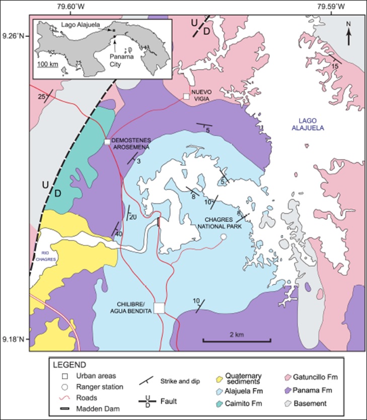
Type Locality is at Lago Alajuela region (Figure 054)
[Figure 054. Geological map of Lago Alajuela region (previously Lake Madden). MacFadden et al. (2017).]
Synonym: Alhajuela Fm; Alhajuela Sandstome Member; Previously included in the Caimito Fm; the Gatún(?) Fm of Reeves and Ross (1930, U.S. Geol. Survey Bull. 821) and Member 1 of sandstone formation of Kellogg (1931, Final report on field investigations of the Madden Dam and Reservoir site at Alhajuela, Panama Canal Zone, Panama Canal Rept.)
Lithology and Thickness
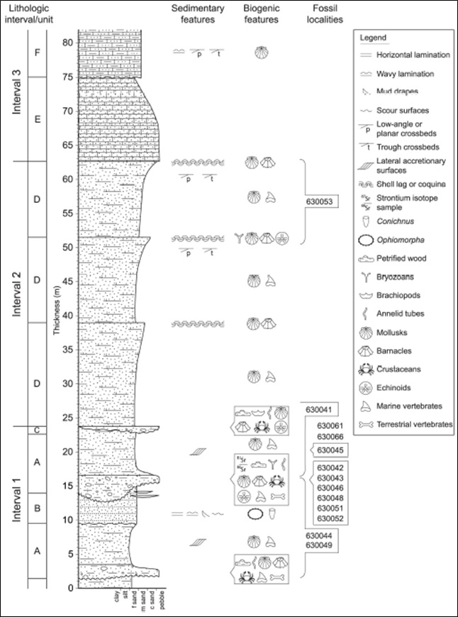
The Alajuela Fm includes a >25 m-thick basal package of interbedded, clast-supported conglomerates and litharenite sandstones that grades into an ~85 m-thick package of calcareous sandstones and calcarenites, representing a transition from tide-dominated, potentially estuarine, coastal environments to wave-dominated, shallow-water carbonate environments. The 82 m-thick composite section (Figure 053), measured in proximity to the fossil localities on the southern extent of Lago Alajuela, is subdivided into three distinctive lithological intervals to summarize major facies transitions during this transgression.
Within the basal Interval 1, laterally extensive horizons of amalgamated conglomerate lenses fine upwards into fine-medium grained sandstones (Unit A), truncated by erosional contacts with overlying units. The best exposed amalgamated conglomerate (near the 15 m level in the composite section) exhibits substantial variability in thickness (1±6 m) with an average thickness of ~3 m. The amalgamated conglomerates are generally clast-supported, but locally matrix-supported, with the coarse grain fraction rarely exceeding 5 cm in diameter. Weathered exposures of the conglomeratic horizons erroneously appear matrix-supported due to diagenetic dissolution of aragonitic shell material. Prior to such dissolution, the coarse fraction would likely have been dominated by mollusk shells, whereas well-rounded, pebble- to cobble-sized volcanic fragments (welded tuff and andesite) and silicified woods comprise the minor component of the coarse fraction. Fossil invertebrate remains primarily consist of internal and external molds of mollusk shells preserved in fine-grained sand matrix as well as some original calcitic shell material of scallops and oysters. The amalgamated conglomerates contain the most abundant vertebrate fossils both well-preserved remains of marine vertebrates (e.g., sharks) and highly weathered remains of terrestrial vertebrates. Interval 1 is tentatively interpreted as sediment deposited in the distal area of a tide-dominated estuary. The amalgamated conglomerate horizons with variable thickness likely represent lag deposits within tidal channels whereas the overlying bioturbated sandstones represent tidal sand bars with lateral accretionary surfaces. (MacFadden et al. (2017))
The base of Interval 2 exhibits a highly irregular, erosional contact with either a poorly sorted, bioturbated sandstone of Unit A lithologies or a laterally discontinuous unit of clastsupported conglomerate (Unit C). This interval typically occurs well above lake levels in the study area and is covered by vegetation. Consequently, continuous fresh exposures exhibiting diagnostic sedimentary structures are relatively rare. The dominant lithology in Interval 2 appears to be a well-cemented, fine-grained litharenite that coarsens upwards into a medium-grained sand capped by a shell lag horizon of fragmented bivalves and gastropods (Unit D). The density of shell fragments at the top of the coarsening-upwards sequences locally approaches that of a coquina. A minimum of three coarsening-upward sequences is preserved in Interval 2, and although the litharenite appears massive in most exposures, trough cross-bedding and low-angle planar cross-bedding are evident locally. (MacFadden et al. (2017))
The base of Interval 3 is marked by a cm-scale gradational contact between an underlying shell lag in Interval 2 and an overlying fine-grained calcareous sandstone with lithics and occasional trough cross-bedding and ripple marks (Unit E). A calcarenite occasionally interbedded with sandy limestone (Unit F) occurs stratigraphically above, separated from the underlying calcareous sandstone by an irregular, erosional contact. Sedimentary structures vary within the calcarenite from trough cross-bedding to wavy bedding to low-angle planar cross-bedding, suggesting substantial changes in flow velocities at the time of deposition. The lithologies in Unit F were originally described by Woodring (1957) as the “Alhajuela” Sandstone Member of the Caimito Fm. However, based on the age constraints presented below for the Alajuela Fm, this attribution to the late Oligocene - early Miocene Caimito Fm is no longer supported. (MacFadden et al. (2017))
Deposits within Intervals 2 and 3 in the composite section are interpreted to have been deposited in wave-dominated nearshore environments. (MacFadden et al. (2017)).
Thickness: 85 metres
[Figure 053. Composite lithostratigraphic section of the Alajuela Fm as exposed in northeastern Chagres National Park, along Lago Alajuela. MacFadden et al. (2017)]
Relationships and Distribution
Lower contact
Upper contact
Regional extent
GeoJSON
Fossils
Age
Depositional setting
Additional Information
References:
- Pilsbry (1918).
- Schuchert Charles (1935)
- A. Olsson (1942b). Correlation chart shows Alajuela as uppermost Member of Caimito Fm. Lower Miocene.
- Woodring W.P, Thompson T.F. (1949) (in their Figure 2). Uppermost Member of Caimito Fm in Madden Basin. Present only in type area. Consists of massive fine- to coarse-grained tuffaceous sandstone. Thickness 275 feet. Late early Miocene or possibly early middle Miocene. The Alhajuela is the Gatún(?) Fm of Reeves and Ross (1930, U.S. Geol. Survey Bull. 821) and Member 1 of sandstone formation of Kellogg (1931, Final report on field investigations of the Madden Dam and Reservoir site at Alhajuela, Panama Canal Zone, Panama Canal Rept.).
- Jones S.M. (1950); Wilson et al. (1957); Woodring (1957);
- Woodring (1960); “Alajuela” was casually used for sandstone at Madden Dam, Panama. The name was later altered to “Alhajuela”, the name of the former village on Río Chagres near the present site of Madden Dam.
- Keroher et al. (1966); Smith (1991); Collins et al. (1996);
- MacFadden et al. (2015a & 2017). Renames the formation back to “Alajuela”.
- Rodríguez-Reyes et al. (2017a, 2017b); Velez-Juarbe et al. (2019)